Chichen Itza developed in the 9th century when the Maya people moved north due to drought. By the 10th century it had become one of the largest Mayan cities and dominated the area, something it did for over 200 years. Famous for its temples and observatory it became one of the Modern Wonders of the World as late afternoon on the Spring and Autumn equinoxes, the north-west corner of the pyramid of Kukulkan - the serpent god - casts a series of triangular shadows on the north side that gives the impression of a serpent moving down the staircase.
Although there was a city in this location as far back as 600 AD Chichen Itza really developed in the 9th century when the cities of Palenque and Tikal were deserted by the Mayas who moved north into the eastern part of Yucatán. It was, however, in the 10th century that the city was to become one of the largest Mayan cities that was to dominate the area from central Yucatán to the north coast and down the east and west coasts of the peninsula. It was to retain its dominance for 200 years.
Its name means "at the mouth of the well of the Itza". The Itza being a group of people who built the second city at the location of a previous city called Chichen, with the site today consisting of two areas.
With relatively densely clustered architecture, the main area of the site covers over 5 square kilometres The residential buildings would have extended far beyond that which is seen today. The area containing the major architectural buildings was artificially leveled in order to build. The site contains many buildings in various states of preservation, and many have been restored. The main ones are explained below.
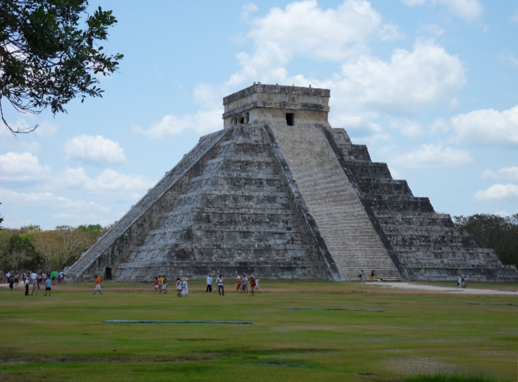
The Temple of Kukulkan - as seen in the main photograph above - the Maya serpent god is usually referred to as El Castillo (the castle). Rising 30 metres (98ft) high on the North Platform the step pyramid consists of a series of nine square terraces, each approximately 2.5 metres (8ft) high, with a temple 6 metres (20ft) high at the summit, the temple is a Jaguar throne.
The four faces of the pyramid have protruding stairways that rise at an angle of 45° with 365 steps.At the base of the balustrades of the northeastern staircase are carved heads of a serpent. Late afternoon on the Spring and Autumn equinoxes, the north-west corner of the pyramid casts a series of triangular shadows on the north side that gives the impression of a serpent moving down the staircase.
Across from El Castillo is The Temple of the Warriors, this complex consists of a large stepped pyramid with rows of carved columns depicting warriors.
At the top of the pyramid is a statue of Chac Mool, although a number of similar ones can be seen at closer quarters.
The Chac-Mool depicts a human figure in a position of reclining with the head up and turned to one side, holding a tray over the stomach, it is suggested that the heart of the sacrificed was placed on the tray.
Along the south wall of the Temple of Warriors are a number of columns, which would have supported an extensive roof system. Some of these columns contain pillars with carvings of soldiers in bas-relief; carvings of people or gods, and animals and serpents.
Leading away from the Temple of Warriors is The Tzompantli or Wall of Skulls,
this is where the heads of sacrificial victims were placed. The platform walls are carved with reliefs of the skull rack itself; a scene with a human sacrifice; eagles eating human hearts; and skeletonized warriors with arrows and shields.
Located to the north-west of El Castillo is the Ball Court. The Ball Court was an important part of Mayan cities with all but the smallest having one, thirteen have been identified in Chichen Itza including the largest found in Mesoamerica. The Great Ball Court measures 168 by 70 metres. At each side of the playing area are platforms 95 metres long and with 8 metres high walls with a ring at the centrally positioned.
The bases are slanted with panels depicting the game and players. At either end of the playing area are temples. Built into the east wall are two temples of the Jaguar, the upper temple overlooks the ball court while the lower temple has a Jaguar throne similar to the one at the top of the Castillo.
The Maya were proficient astronomers who had mapped many of the celestial objects, particularly Venus and the Moon and their calculations enabled them to produce precise calendars. Many of the buildings were aligned to the heavens and were used in their observation, although the round buildings tended to be labelled as observatories.
Such a building is El Caracol mounted on a large square platform.
The Nunnery was so named by the Spanish and was in fact a palace complex. To the east is a small temple known as the Church which is decorated with elaborate masks and hieroglyphic texts.
Around the area are a number of natural sinkholes known as cenotes, Chichen Itza has two providing water to the city throughout the year. The large one is 60 metres in diameter and drops 27 metres to the water table. This cenote is also known as the Well of Sacrifice as it was used by the Maya to sacrifice objects and people to Chaac, the rain god. Objects such as gold, carved jade, pottery, flint, obsidian, shell and human remains have been found at the bottom of the cenote.
Much of Chichen Itza has still to be excavated and this is an ongoing process. As it is within travelling distance of the tourist resorts it is one of Mexicos most visited sites and makes the most of this by catering for tourism with souvenirs and a sound and lights show.
To see more photographs and take a virtual tour of the site click on the photoshow below.