

|
|
|
|||||||||||||||
|
|
||||||||||||||||
|
|
|||
|
|
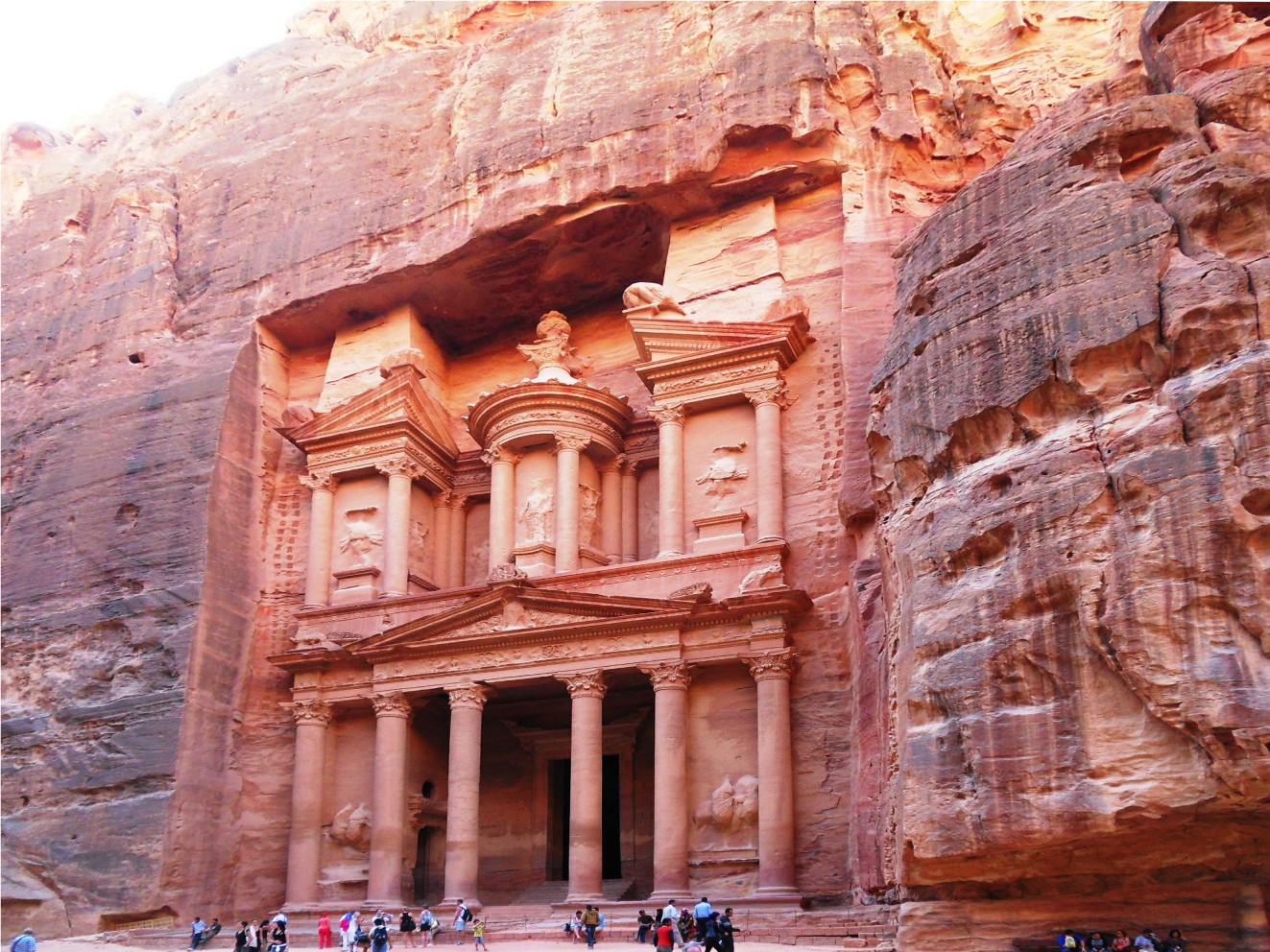
Petra is known as the "rose-red city" because of the rose-red colouring of the rock. It is situated in the south of Jordan and is surrounded by mountains. Although Petra is generally associated with the Nabataeans, the remains of a settlement have been found there which date back to the 6th century BCE. Petra developed due to the plentiful supply of water and the natural defensive position of the land. It is known that a settlement existed there between 1550-1296 BCE as it is referred to in the accounts of the Egyptian campaigns of the 18th Dynasty. The Nabataeans constructed massive rock-cut architecture and an ingenious complex of dams and water channels. At its peak in the 1st century BCE and AD, the Nabateans controlled as far north as Damascus in Syria, as far south as Northern Arabia and also over parts of the Sinai and Negev deserts. The Nabataeans prosperity came from Petra's location on the incense, spice and silk trade routes, which linked China, India and Southern Arabia with Egypt, Syria, Greece and Rome. Due to its plentiful water supply, it provided a stopping place for the caravans travelling between these places. In 64 BCE, the Romans under Pompey arrived, which curtailed any further expansion by the Nabataeans and in 106 AD, Petra was absorbed into the Roman Empire, and the Nabataean dynasty came to an end, although the city continued to flourish. In the 13th to 15th centuries AD, it once again became a stopping place for caravans, although it did not regain its commercial importance, and was subsequently inhabited only by local Bedouins until it was rediscovered in 1812 by the Swiss explorer Johann Ludwig Burckhardt. The city is reached through a narrow gorge over 1 kilometre (0.6 miles) in length, with steep rising sides over 80 metres (262 feet) high called the Siq ("the shaft"). 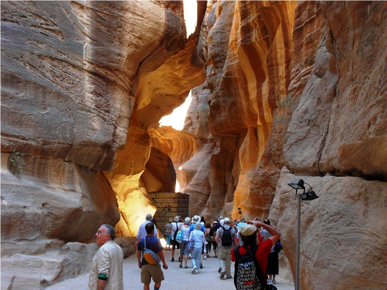   This is a natural geological feature formed from a deep split in the sandstone rocks, which opens into a natural square dominated by Petra's most famous monument known as The Treasury (El-Khazneh).  The purpose of the Treasury is not known for certain, although it is accepted that it was not in fact a treasury. It has been suggested that it is a memorial mausoleum. However, excavations conducted below the building indicate that it was a royal tomb. The date of its construction is also unclear, although it is probable that it was constructed by Aretas III Philhellene (86-62 BCE), at a time of great expansion. Having been carved from the cliff face, it has an intricately carved facade that is 30 metres (98 feet) wide and 43 metres (141 feet) high.   The area also contains over 800 other monuments which include buildings, baths, and funerary halls. There is a theatre with a capacity for over 8,000 people which was constructed in the 1st century AD by the Nabataeans. Construction consisted of both carving it from the rock and from it being erected.  The Royal Tombs are set into the rock face of the Jabal Al-Khubtha and are amongst the most impressive of the 500 tombs found in Petra. The Urn Tomb which was probably constructed around 70 AD was adapted in 446 AD to serve as a Byzantine church, the vaults of which can still be seen below the tombs. The tomb was named after the stone urn that sits above the pediment. This was an important tomb, probably one of the Nabataean Kings. It is possible that it was used as a courthouse during Roman times.  The Obelisk Tomb was carved by the Nabataeans in the 1st century AD. Below this is a banqueting hall which is known as a Triclinium. 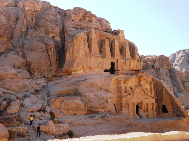 The Temenos Gate was constructed in the 2nd century AD, after the completion of the Colonnaded Street in order to act as a ceremonial entrance to the sacred precinct. This seems to be known by a number of names such as Hadrian Gate and the Triple Arched Gate. 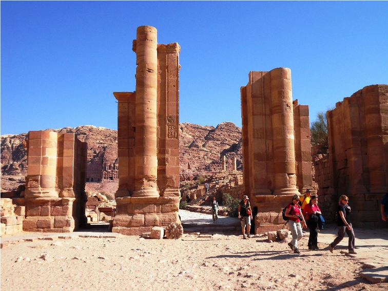 Within the sacred precinct is the Qasr Al-Bint Temple constructed around 30 BC - 40 AD. It is the only substantial stone-built structure in Petra still standing amongst the multitude of buildings hewn from the rock. Originally it would have stood 23 metres (75 feet) high with a marble stairway and hallway lined with statues.  In front of the temple is a large altar, indicating that offerings were made outside of the temple. Petra was designated a UNESCO World Heritage Site in 1985.
To see more photographs and take a virtual tour of the site click on the photoshow below.
Additional information can be found on Encyclopaedia Britannica |
|
|
|
|
|||
All Photographs were taken by and are copyright of Ron Gatepain
| Site Map |